
Great 8: Wow Waterfalls
Peruvian painter Macedonio de la Torre is credited with saying, "You cannot hear the waterfall if you stand next to it. I paint my jungles in the desert." One surmises that he was suggesting that a bit of distance offers artistic perspective. In other words, in order to truly appreciate a wonder you have to remove yourself from the moment. Then again, maybe he never visited these eight waterfalls:
Niagara Falls
One of the best things about Niagara Falls is the viewing options. You can marvel at it up close--aboard a Maid of the Mist boat tour on the American side. You can pose for a selfie with one of the Seven Natural Wonders as you stand atop Rainbow Bridge connecting the U.S. with Canada. And on the kitschier Canadian side, you can board the Niagara Skywheel, a Ferris wheel that offers a fantastic view from 175 feet up.
Or maybe some facts offer perspective: Did you know the falls are somewhat misnamed? Yes, there are two primary falls--American Falls and Horseshoe/Canadian Falls (which are more majestic, sending mist several hundred feet high). According to the U.S. Geographical Survey, however, nearly one-third of Canadian Falls lies within U.S. territory. Did you know that Niagara Falls is moving backwards? The 750,000 gallons of water per second that flow over the falls actually wear down the rim one or two feet each year. So over the millennia, the falls have moved several miles upstream. And did you know that once--on March 29, 1848--the flow of water at both falls stopped completely? Niagara Falls never actually freezes in the winter, but on this day an ice jam in the upper river plugged it up. People actually walked out and picked up artifacts from the riverbed. One assumes they retreated before the falls started up again.
Multnomah Falls
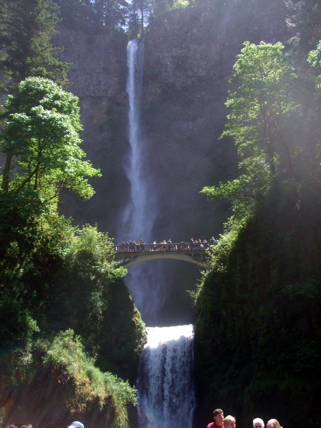
Oregon's Columbia River Gorge may be to waterfalls what Yellowstone is to geysers. If that's the case, the Old Faithful of the region has to be Multnomah Falls, one of North America's iconic experiences. Fed by underground springs from Larch Mountain, this 620-foot, two-tiered marvel plummets into a misty forest grotto. Amid beautiful landscape, it's a scenery stealer.
Nearly two million people visit Multnomah annually, but far fewer actually try to climb to the top. Start with a gently sloped trail for about a quarter-mile, which takes you to 97-year-old Benson Bridge, named after Simon Benson, one of the guys who built the old scenic highway along the river. The bridge, which essentially spans the spot where the upper falls become the lower falls, is said to be perhaps the most photographed piece of architecture in Oregon.
From there, follow a paved series of switchbacks up for another mile until you reach a ridge crest offering a remarkable view of the Columbia River, the falls and the less adventurous people below. And there is actually a Native American legend about that spot. The story goes that the chief's daughter was told by the Great Spirit to jump from the cliff in sacrifice. And she did. When the devastated chief asked the Spirit to give him a sign that his daughter did not die in vain, water began to cascade from the cliff. Hence, the falls.
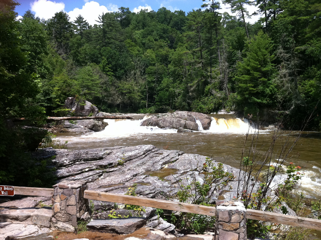
Brandywine Falls
In the pantheon of U.S. national parks, Yellowstone, Grand Canyon and the like are the kings. A notch below that, at least on the general public's radar, are the Dukes of Natural Wonder--place like Carlsbad Caverns and Crater Lake. Then there are the ones unknown by much of the U.S. population, although national park enthusiasts will rave about them--California's Kings Canyon, for instance, and Washington's North Cascades. Finally, there's Cuyahoga Valley National Park. It's just a few miles south of Cleveland. When you think of national parks, you don't think of Cleveland.
Chances are you didn't know it existed. It has only been an official national park for barely a decade. But it's actually one of the ten most visited national parks in the country--roughly 2.5 million people per year, which would place it roughly between Zion and Grand Teton in popularity. It helps, of course, that Interstate 80 passes right through it. Cuyahoga means "crooked," a reference to the 90 miles of twists and turns of the Cuyahoga River. The national park consists of 33,000 preserved acres along 22 miles of the river between Cleveland and Akron.
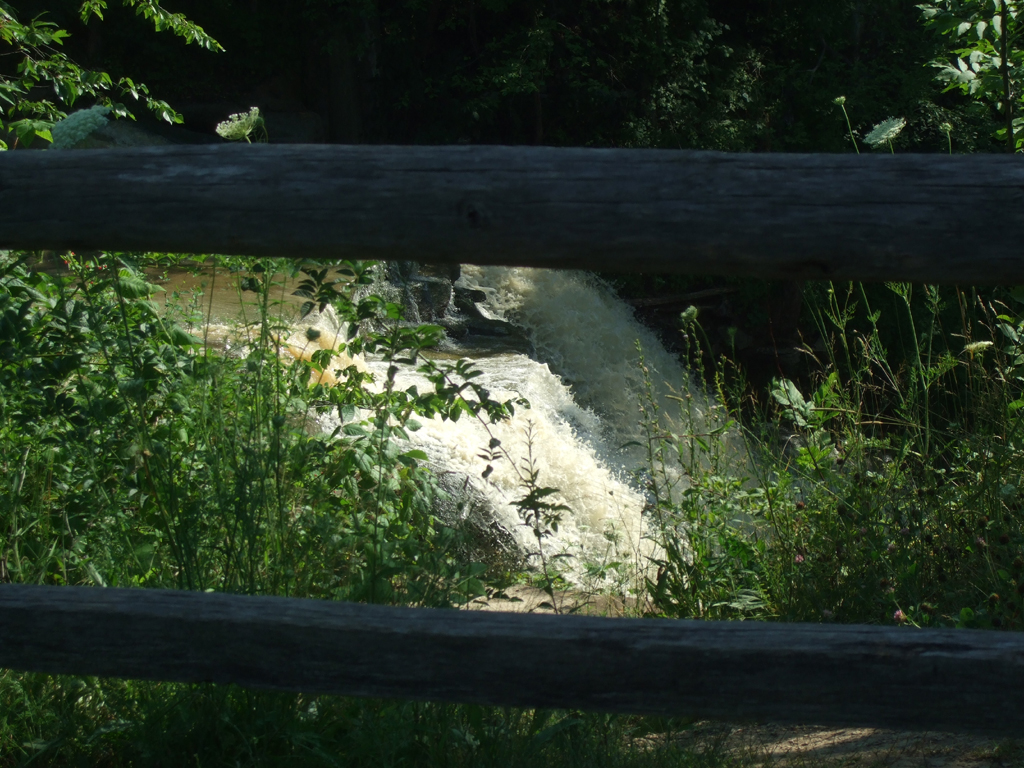
The options and attractions are many, including biking trails, horse trails, scenic railroads, and a historic village. Or you can opt for a one-a-half-mile hike along the road and path and boardwalk that constitutes the Brandywine Gorge Trail, which starts and ends at 60-foot Brandywine Falls. Yep, right near Cleveland.
McWay Falls
This must-see stop along the Big Sur coast offers is a before-and-after perspective. Turn off the Pacific Coast Highway into Julia Pfeiffer Burns State Park, 37 miles south of Carmel, and set off for a short hike along Ewoldsen Trail. The trail leads inland alongside McWay Creek, weaving its way through some modest redwoods until finally it arrives at a wooden bench and a tiny waterfall at the path's end. Here, a few upended trees have crashed across the creek and over one another like discarded Lincoln Logs. You can sit on the bench and listen as the water gurgles a story about what might have happened to turn an orderly grove into a hodgepodge of fallen majesty.
But this trail's end is actually more of a beginning. As you retrace your steps toward the trailhead, you can watch the stream grow. Return to the parking lot, descend a series of wooden stairs, pass through a little tunnel under Highway 1, and emerge at the sea. There will be eucalyptus trees to your right, a 64-million-square-mile ocean to your left. Halfway down the trail, if you turn back slightly, you'll see that McWay Creek has now become McWay Falls, pouring over a rocky bluff and plummeting more than fifty feet into an idyllic cove. It looks like a shipwreck fantasy.
Linville Falls
By the time you get to Milepost 316 along the North Carolina stretch of the Blue Ridge Parkway, maybe you've already gasped and gawked your way south from Virginia. In fact, only a few miles earlier, perhaps you passed over Linn Cove Viaduct, a 1,243-foot segmental concrete bridge that curves around the side of Grandfather Mountain. So you wouldn't think the wow factor would be so high regarding Linville Falls. But then, after walking a couple of miles to get fine view of the falls, you discover a force of nature. Literally. The Linville River begins on the steep slopes of Grandfather Mountain. By the time the river reached the falls, especially if you're visiting after a particularly rainy stretch, it is rushing with incredible force. Impressive, even by Blue Ridge standards.
Of course, rushing is not what a Parkway drive is all about. In fact, after your Linville Falls hike, drive another 18 miles to a blip known as Little Switzerland, home of the Switzerland Inn and Chalet Restaurant. Put your feet up at an outdoor patio, order a fried green tomato BLT, and enjoy a delicious view of North Carolina's majestic peaks.
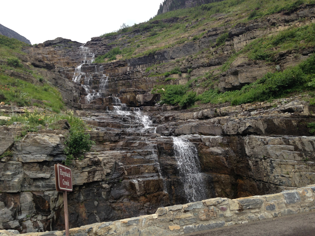
Haystack Falls
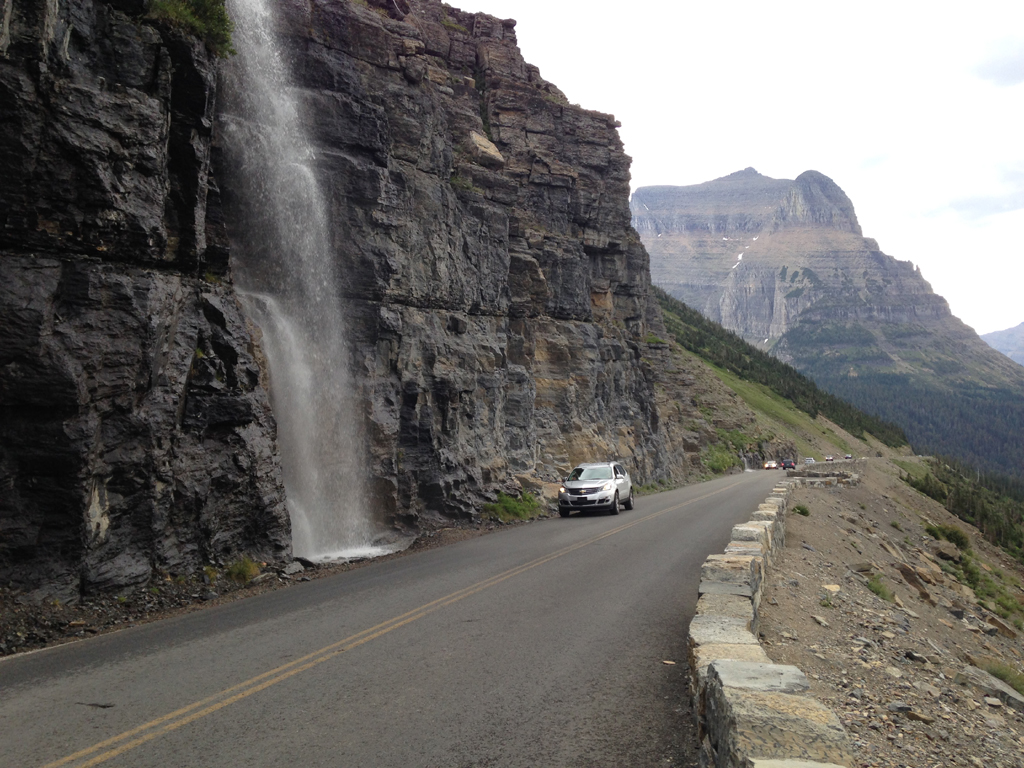
There are waterfalls galore in Montana's Glacier National Park. You can hike to Virginia Falls and St. Mary Falls along the Nature Point Trail. Or Red Rock Falls near Many Glacier. Or Running Eagle Falls near Two Medicine. Or any of the other more than 200 waterfalls that serve as a cascading complement to the myriad wonders in the park. But even if you don't feel like hiking a bit or exploring Glacier's less-explored regions, you can find a "whoa" waterfall.
Going-to-the-Sun Road is a remarkable achievement, bisecting Glacier National Park for 50 miles through scenery that is both sweeping (grand vistas that rival any park anywhere) and weeping (water pours onto the road along the Weeping Wall). Among the waterfalls along the way are McDonald Falls (two miles west of Lake McDonald Lodge), Bird Woman Falls (which drops 500 feet), and Baring Falls (at the Sunrift Gorge Turnout). But if you truly want to appreciate the road, drive over Haystack Falls. Really, you're essentially driving over it. The falls pour down a nature-made staircase, then rush beneath the road (a small bridge, actually) before plummeting toward the valley below. Awesome.
Kootenai Falls
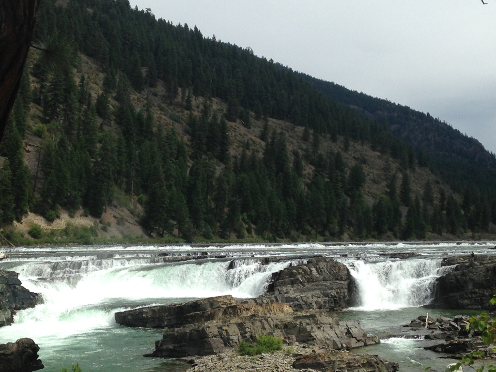
U.S. Highway 2 between the Montana towns of Libby and Troy is not the most well-traveled route in America. But in the summer months the parking lot at Kootenai Falls, about midway between the towns, may be brimming with cars and RVs--and not just because of the sense of danger.
A footpath winds through the trees to the falls, which are product of momentum, as the Kootenai River enters a canyon, surges through China Rapids and then cascades over Kootenai Falls, dropping 90 feet in less than a mile. This is a sacred place to the Kootenai Indians whose ancestors inhabited the region. Of course, that hasn't stopped filmmakers from setting movies there, including Meryl Streep's The River Wild and Leonardo DiCaprio's Revenant. So it's a menacing silver screen setting, even if it's a serene real-life spot.
No, the danger--and it's only a sense of peril for some people--comes at the end of another footpath, this one leading to a bridge spanning the river. It's a Swinging Bridge, 200 feet long, the kind of structure where the sign insists no more than five people cross at a time. Sure, it doesn't appeal to anyone who suffers a fear of heights. Or anyone who has a fear of drowning. Or, since it certainly swings, anyone with a tendency toward motion sickness. But it's entirely safe. And what a view.
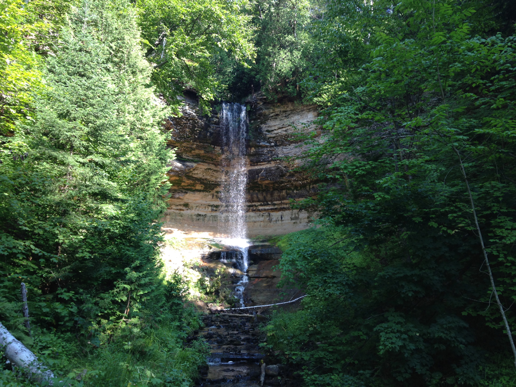
Munising Falls
There are countless breathtaking waterfalls along Pictured Rocks National Lakeshore on Michigan's Upper Peninsula. Miners Falls is mighty, especially when viewed from 77 steps down on a lower platform. The best view of Sable Falls is 169 steps down. Mosquito Falls is home to beavers and river otters. And remote Spray Falls plunges 70 feet over the Pictured Rocks cliffs, right into Lake Superior (and at the base of the falls, in 20 feet of water, are the remains of an 1856 shipwreck).
But there's something about Munising Falls. It's not because it can be found within the city limits of Munising, Michigan (in the westernmost portion of Pictured Rocks), making it probably the easiest of Alger County's 17 waterfalls to visit. And it's not really because the short stroll to the falls offers welcome tranquility--an 800-foot paved trail through a fern-lined sandstone canyon along Munising Creek. It's not even the point-of-view possibilities--an accessible viewing platform and two other viewing areas reached by stairs.
No, there's something about the setting--a 50-foot waterfall dropping over a sandstone cliff. If you stand in the right spot, the scene is framed by the trees. And if you arrive at the right time of day, the sunlight becomes a spotlight on the falls. Simple yet magical.
Comments
Comments on this post are moderated, so they will not appear instantly. All relevant questions and helpful notes are welcome! If you have a service inquiry or question related to your RV, please reach out to the customer care team directly using the phone numbers or contact form on this page .