
Great 8: Under-appreciated Places
In your hurry to add American icons to your been-there-done-that list, don't forget to look around a bit. You might visit a place--a city, a state, a region, a national park--and head straight for the best-known attraction around. In the Black Hills, it's Mount Rushmore. But don't forget the Crazy Horse Memorial or the Presidents Walk in Rapid City. In Springfield, Massachusetts, it's the Basketball Hall of Fame. But the Dr. Seuss Sculpture Garden is a pleasure. In Memphis, you might visit Graceland or the National Civil Rights Museum or Beale Street. But what about Mud Island?
Surely, there are folks who visit Yellowstone, but don't drive another hour to marvel at Grand Teton National Park. And there are people who make their way to the top of Pike's Peak in Colorado Springs, then shrug off a stroll around Garden of the Gods. Yet these are the kinds of places that shouldn't be overlooked. So let's celebrate a handful of them. Here are eight that everyone should appreciate:
Great Sand Dunes National Park
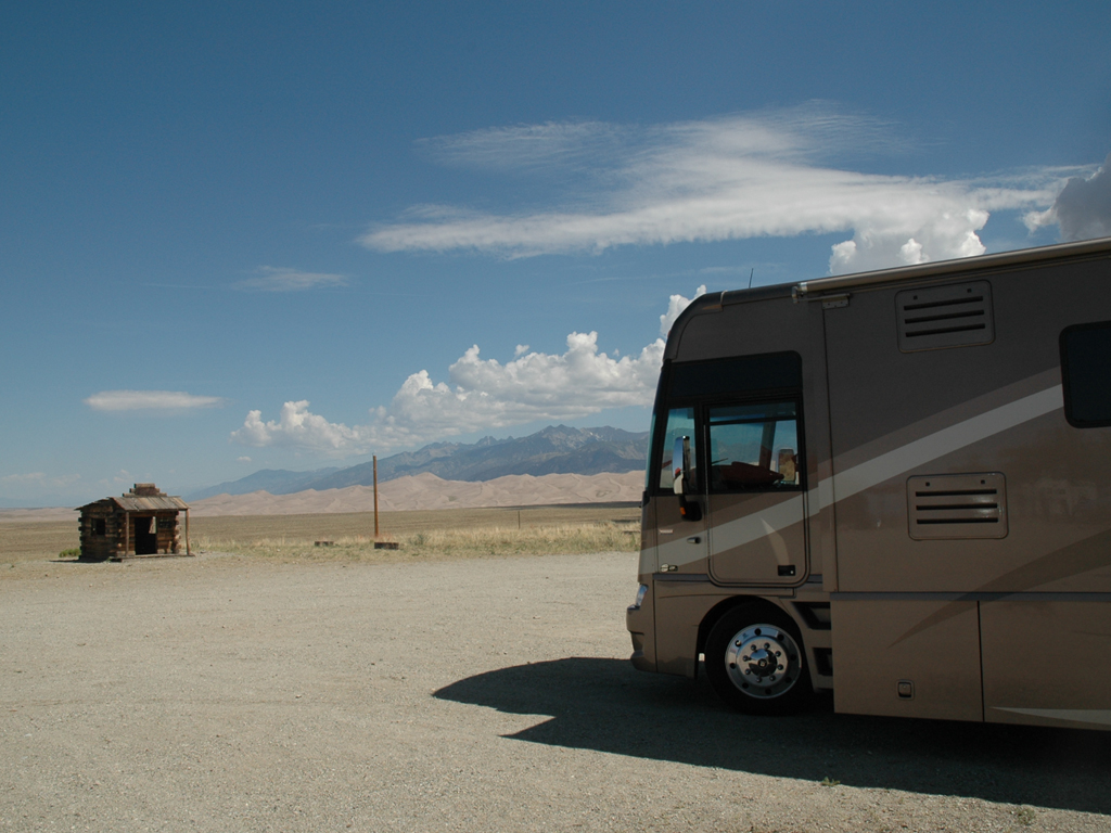
Ask the typical American to name a national park, and how long do you think it would take for someone to name southern Colorado's Great Sand Dunes? The dunes were once a landmark for travelers--from Navajos to gold miners to homesteaders. But Great Sand Dunes isn't Yellowstone or Yosemite or even Arches or the Everglades. Located 35 miles northeast of Alamosa, it's not an easy stop en route to a popular destination. Even in Colorado, it seems to be overshadowed by the likes of Rocky Mountain National Park and Aspen and Telluride.
Still, wow. They're the tallest dunes in North America, comprising about one-tenth of a massive sand deposit that covers more than 300 square miles. Nestled against the rugged peaks of the Sangre de Cristo Mountains and part of 150,000 acres of grasslands, wetlands, forests and alpine lakes, they're picture-postcard dramatic--especially after a drive through the flatlands of Kansas and eastern Colorado.
You can try to reach the top of the tallest. People do it all the time. Just remember that loose sand is a challenge... and it feels close to vertical, rising several hundred feet... and you're already stating at an elevation of about 8,200 feet. Even if you don't complete the mission, you can park yourself at the Great Sand Dunes Oasis campground and watch the sun set over the dunes, and you'll feel like you've made it.
Chattanooga
Quick, what comes to mind when someone mentions Tennessee? Maybe Graceland and Beale Street in Memphis. Or Nashville and the Grand Ol' Opry. Or Gatlinburg and the Gateway to the Great Smoky Mountains. But Chattanooga? It isn't necessarily top of mind, though perhaps it should be. Why? Well, it's a work of art, actually. The Bluff View Art District, not far from the downtown center, offers turn-of-the-century architecture along with a two-acre sculpture walk atop a cliff along the Tennessee River (the River Gallery Sculpture Garden).
The Chattanooga area's two most famous attractions are masterpieces, too. They're located only a few miles apart on Lookout Mountain and are often marketed as a package, although they're actually located in two different states. Ruby Falls, in Tennessee only a couple of miles off of I-24, is a 145-foot underground waterfall--a remarkable cave-and-cascade combo. Take an elevator ride down 1,100 feet and grab an every-15-minutes tour of the caverns, concluding with the sight of water emerging from a three-foot hole in the ceiling of the largest chamber and widening gradually until it plunges into the pool below. Illuminated by colored lights, it is performance art. And Rock City Gardens, on the Georgia side of the mountain, is a 4,100-foot maze of woodland paths and gardens that takes you through rock formations with names like Fairyland Caverns and Goblin's Underpass and Needle's Eye before culminating in the ultimate Lookout lookout--the Seven States Flag Court. You may or may not actually be able to see seven states from there, but the view is sublime--nature's finest art.
Franconia Notch State Park
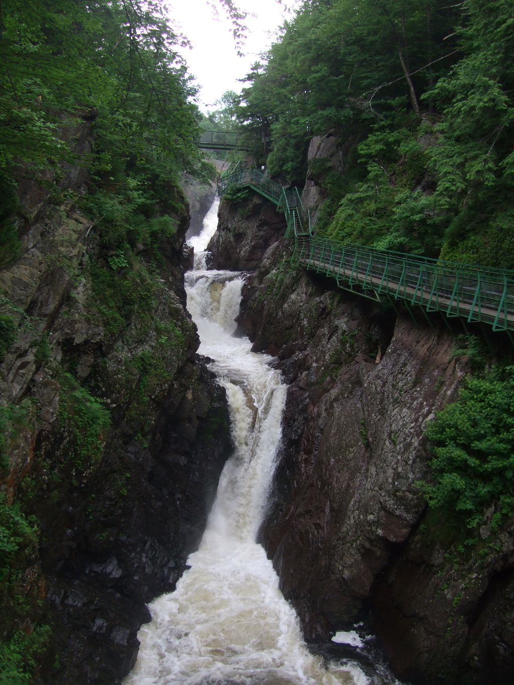
If an epic road trip can be compared to a big screen movie, the national parks are the stars. They're beautiful. They're famous. Everyone wants to be near them. But America's state parks? They're the character actors, often overlooked, sometimes unknown, occasionally more impressive. Franconia Notch State Park, a spectacular mountain pass in the heart of the White Mountain National Forest, fits the bill.
One of the prettiest state parks you'll ever see, it used to be famous for the Old Man of the Mountain (nicknamed Great Stone Face)--five separate granite ledges that formed a man's profile some 40 feet high and 25 feet wide. Alas, the rock formations collapsed in 2003. The Old Man perished. But Franconia still has a lot to offer, whether you want to fly fish in Profile Lake, swim in Echo Lake, or take the Cannon Mountain Aerial Tramway. But there's one can't miss--a walk into the Flume Gorge. It's a natural granite gorge extending 800 feet at the base of Mount Liberty. Walls 90 feet high. Cascading waterfalls. Wooden walkways taking you into the wonder. Trails through the woods taking you out a couple of miles later. Just may try to remain stone-faced, but you'll be grinning most of the time.
Little Rock's Central High School
A trek toward the Deep South and the iconic places in its civil rights history may take you to Memphis and the National Civil Rights Museum, located in the old Loraine Motel where Martin Luther King, Jr. was assassinated. Or maybe Montgomery, where the National Civil Rights Memorial is inscribed with the names of dozens of martyrs for the cause. Or just west from there--to the famous Edmund Pettus Bridge celebrated in the movie "Selma." But don't forget about Little Rock.
The nation watched a desegregation drama play out in 1957, as a group of young men and women who came to be known as the Little Rock Nine attempted to become the first African-Americans to enroll at Central High School. Arkansas Governor Orval Faubus called in the Arkansas National Guard to keep the black students out. So it was decided that the students (and a group of chaperones) would arrive together at the school. However, word never reached 15-year-old Elizabeth Eckford. When she arrived at Central, she found herself facing a menacing mob--the photos proved to be some of the most haunting images of the time. President Eisenhower sent in the troops to face down Faubus, and the school was integrated, marking the beginning of the end of a separate-and-unequal era.
Today, Central High School is a National Historic Site. There is a visitor center located across the street from the school, as well as a Commemorative Garden featuring nine trees and benches that honor those courageous students. It all used to be located on a road known as 14th Street. But the street is now named after a local woman who was a pivotal figure in the integration process--Daisy L. Gaston Bates Drive. Sometimes, when you visit a place like this, it's a reminder that we've all come a long way.
Havre Underground
U.S. Highway 2 along Montana's Hi-Line, the northernmost swath of the state, isn't what you would call a busy thoroughfare. But most folks who pass through Havre (pronounced HAV-er) or even purposefully visit Havre and wander around a bit may not realize that they can also stroll underground.
Once home to bootleggers and railroaders, Havre sprang up almost overnight as a supply depot for the Great Northern Railway. But after a 1904 fire burned down the wooden structures that constituted most of the town, destroying more than 60 businesses, many of the residents moved temporarily into their basements. They dug tunnels to connect them. They built skylights to illuminate their underground world. While the town was being rebuilt, business carried on in the form of somewhat respectable below-ground establishments--a dentist, a druggist, a butcher, a barber, a baker. But when the above-ground city returned, the underground became a bit darker.
Today, more than a century later, you can explore Havre Beneath the Streets, reliving the strangeness and debauchery via an hour-long guided tour. Your below-ground guide will tell you tales about the opium den and the bordello and the Sporting Eagle Saloon and the fellow named Shorty who lorded over it all. The cold stone walls and low stained ceilings--and most of all, the wax figurines here and there--will creep you out. The stories will make you smile--or wince. The combination makes it a largely unknown attraction that emerges as unforgettable.
Plains, Georgia
It may be the best-known presidential hometown in the country, right up there with Independence (Harry Truman's Missouri) and Hope (Bill Clinton's Arkansas). However, that doesn't mean it's necessarily high on the typical to-visit list. But even if you're not a presidential historian, the old stomping grounds of President Jimmy Carter are worth a stop.
A hiccup of a hamlet (776 residents) about an hour southeast of Columbus, Plains still very much celebrates its native son, the 39th U.S. president. Carter's boyhood farm, the train depot that housed his presidential campaign headquarters in 1976, and the local high school are all part of the Jimmy Carter National Historic Site (his private residence is still located in Plains, too). You can even visit the Billy Carter Service Station Museum, a quirky collection in the service station once owned by the President's colorful brother. Remember Billy Beer?
But forget the beer. If you're going to Plains, you better leave with some peanuts. There's a shop there called Plain Peanuts that sells the southern delicacy of fried peanuts, along with peanut butter fudge and peanut brittle and peanut butter ice cream. And really, is there any combination of taste and place as iconic immersing yourself in everything peanut in the hometown of a peanut-farmer-turned-president? It is what Bar Harbor is to lobsters, what New Orleans is to po-boys. It's an experience.
Point Lobos State Reserve
It's not that the tourists skip Point Lobos; they don't--it's often crowded with hikers and gawkers. It's just that a number of destinations on California's Monterey Peninsula--Pebble Beach Golf Links, the Monterey Bay Aquarium, Carmel-by-the-Sea--tend to be visitors' higher priorities. But Point Lobos, just south of Carmel along Highway 1, offers the opportunity to climb inside a literary classic. You see, Robert Louis Stevenson lived in the area just before he wrote the book that made him famous in 1883--Treasure Island. He may have based the setting on Point Lobos.
Point Lobos isn't an island at all, but the similarities are intriguing. Bird Island? That could be Stevenson's Skeleton Island. Big Dome bears a resemblance to Stevenson's Spyglass Hill. The grove of native cypress trees? The author calls it the Cape of the Woods. Take Carmelo Meadow Trail to Whalers Cove and watch otters cavort while you listen to the distant bark of sea lions (the book's young hero, Jim Hawkins, described them as "huge slimy monsters, soft snails, as it were, of incredible bigness.") On the other side of Whaler's Cove, 150-year-old Whaler's Cabin may remind you of the old fort in the novel, the site of a bloody battle between the good guys and the pirates--the place where Long John Silvers himself, peg-legged and parroted, shouts, "Them that die'll be the lucky ones."
Meanwhile, some of their plunder is said to be buried still on that fateful isle... Yo-ho-ho, and a bottle of rum.
North Dakota
North Dakota was once described, long ago by CBS newsman and native son Eric Sevareid as "a large rectangular blank in the national consciousness." It has been accidentally left out of a Rand McNally atlas (well, a portion of it in 1989). And an article in a 1995 issue of New York Times Magazine asked, "Is North Dakota necessary?" So it's tough being the more northern, less touristy Dakota. But to appreciate the state, all you have to do is drive through it.
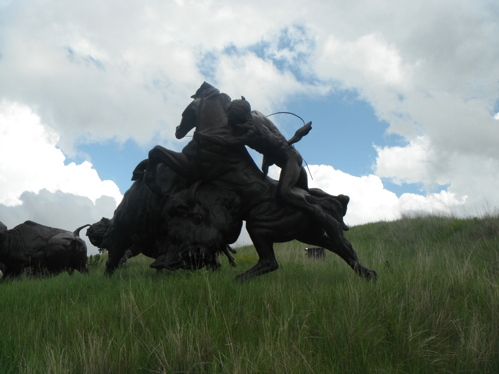
From the west, you might start with the restored western town of Medora, Gateway to Theodore Roosevelt National Park (South Unit), home of the nightly Medora Musical, the Rough Riders Hotel, and the North Dakota Cowboy Hall of Fame. Of course, before the cowboys came, the buffalo roamed. So cross the mighty Missouri River at Bismarck, then make your way east to Jamestown and the National Buffalo Museum, where a herd of bison (including a couple of rare albino animals) roam 200 acres on either side of Interstate 94. Just a few steps from the museum is Frontier Village, a reconstructed 19th century prairie town. And standing guard over it all, just a couple hundred feet further, is a 26-foot-tall, 46-foot-long cement sculpture known as Dakota Thunder, the World's Largest Buffalo.
Or take North Dakota's back roads--past endless hay fields--to towns with evocative names. Like Zap, where the "Zip to Zap" (an attempt at a Woodstock-like experience a few weeks before Woodstock in 1969) was a bit of a failure. Or like another town called Hope, a pleasant little community in the shadow of a white water tower. HOPE is emblazoned on one side, a smiley face on the other.
Comments
Comments on this post are moderated, so they will not appear instantly. All relevant questions and helpful notes are welcome! If you have a service inquiry or question related to your RV, please reach out to the customer care team directly using the phone numbers or contact form on this page .